


|
||

|

|
|

|
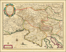
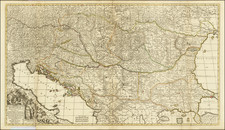
Detailed large format map of Hungary, Slovenia, etc., extending west to east from Drendorf to Guila Feyrwar, and north to south from Ormitz to Belgrade.
Uncommon two-sheet map originally prepared by Price for the unsucessful partnership of Price, John Senex and John Maxwell (1708-1711). After the partnership broke up, each member took the plates that they engraved with them, the majority of which were engraved by Senex and were re-issued in his 'English Atlas' from 1714. In 1713, Willdey acquired the remainder of Price's stock and began to issue them with his own imprint and in a further ill-fated partnership with Timothy Brandreth. The partnership was not a commercial success and, by later the same year, Willdey was advertising the remaining stock of maps at a heavily discounted price.
John Senex (1678-1740) was one of the foremost mapmakers in England in the early eighteenth century. He was also a surveyor, globemaker, and geographer. As a young man, he was apprenticed to Robert Clavell, a bookseller. He worked with several mapmakers over the course of his career, including Jeremiah Seller and Charles Price. In 1728, Senex was elected as a Fellow of the Royal Society, a rarity for mapmakers. The Fellowship reflects his career-long association as engraver to the Society and publisher of maps by Edmund Halley, among other luminaries. He is best known for his English Atlas (1714), which remained in print until the 1760s. After his death in 1740 his widow, Mary, carried on the business until 1755. Thereafter, his stock was acquired by William Herbert and Robert Sayer (maps) and James Ferguson (globes).

![(Second World War - Operation Barbarossa) A M. Kir. VIII. Honv. LGV. O. Hazamenetelének útja mecsebjelovkától kassáig [The Hungarian 8th Anti-Aircraft Battalion's Homeward Route from Mechebylove to Kosice]](https://storage.googleapis.com/raremaps/img/small/90242.jpg)