
This item has been sold, but you can enter your email address to be notified if another example becomes available.


|
||

|

|
|

|
Stock# 21082
Description
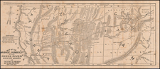
A fine example of HH Lloyd's scarce double page map of this portion of the Transmississippi West, centered on the Rocky Mountains.
Tremendous detail throughout, too much early information to describe in detail. Includes counties, towns, railroads, mountains, rivers, explorer routes, US Mail Route, Indian lands and a host of other details. HH Lloyd never did issue his Atlas of the United States, but portion appeared in Warner & Beers Atlases during the 1870s.
![Map of Oregon Territory. By Samuel Parker. 1838. [with:] Journal of an Exploring Tour Beyond the Rocky Mountains, under the direction of the A. B. C. F. M. 1840.](https://storage.googleapis.com/raremaps/img/small/97939.jpg)

![[ Southern Railroads ] Railroad Map of the Southern States Shewing the Southern & Southwestern Railway Connections With Philadelphia. 1862 . . . Prepared by Thomas Kimber Jr., Chairman of the Committee on Inland Transportation of the Board of Trade of Philadelphia](https://storage.googleapis.com/raremaps/img/small/103211.jpg)
![(Texas - Spanish Colonial Era) [Manuscript document of 1692 concerning Bahia del Espiritu Santo on the Texas Gulf Coast, signed by the Viceroy's secretary, Juan Francisco de Vargas Manuel de Lodeña]](https://storage.googleapis.com/raremaps/img/small/95766.jpg)