
The item illustrated and described below is sold, but we
have another example in stock. To view the example which
is currently being offered for sale, click the
"View Details" button below.


|
||

|

|
|

|
Stock# 21040
Description
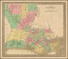
Striking full color example of the first edition Greenleaf's map of Louisiana, which appeared in his Universal Atlas, first issued in 1842.
The Parish system is still quite primitive, especially in the North and West, where 7 parishes dominate the region. The early roads are shown, although few traverse the state from north to south. The North and West are still dominated by Indian Lands and Prairie.

![[ Southern Railroads ] Railroad Map of the Southern States Shewing the Southern & Southwestern Railway Connections With Philadelphia. 1862 . . . Prepared by Thomas Kimber Jr., Chairman of the Committee on Inland Transportation of the Board of Trade of Philadelphia](https://storage.googleapis.com/raremaps/img/small/103211.jpg)