|
||

|

|
|

|
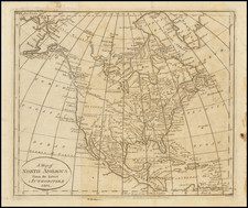
Joutel's map of North America illustrated one of the most important accounts of early French exploration of the Mississippi Valley region. The map illustrates the regions explored by La Salle between 1681 and 1686, as well as the route taken by La Salle and later by Joutel and his group of survivors, as they proceeded north from Texas to the Mississippi River and ultimately up the Mississippi to the more established French Colonial strongholds in Canada.
While Joutel's report appears periodically on the market, the map itself is very rarely offered separately, this being the first example we are aware of in the past 20 years.
Joutel's report is the premiere account of La Salle's tragic final voyage, compiled from the diary of his close subordinate. The party embarked in 1684, ostensibly to establish a French base at the mouth of the Mississippi as headquarters for operations, but as well to push as far as possible into the region in order to gain a foothold against the Spanish. In fact, and via a conscious deceit, the base was established at Espiritu Santo Bay, in Texas, where the party spent two years making excursions into the surrounding territory. When expected reinforcements failed to appear, La Salle and his men determined to return to Canada via the Mississippi. Unfortunately for La Salle, a member of the expedition assassinated La Salle when they reached the Trinity River, and the company split up. Some of the survivors, including Joutel, pressed on, reaching Canada by way of the Mississippi and Arkansas rivers.

![[Texas Coast] Partie Du Mexique Amer. Sep. No. 60.](https://storage.googleapis.com/raremaps/img/small/93536.jpg)