


|
||

|

|
|

|
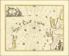
Scarce chart of the Bay of Cardenas, just east of Havana. Edged in red silk. Color (yellow and red) to lighthouses. Pencil lines showing plotted courses.
The charts produced by the 'Direccion de Hydrografica' were detailed surveys meant for marine use. Not unlike the well known blue-back charts of the British Hydrographic Office, these Spanish charts were taken aboard vessels and used the same way as modern coastal charts are today. Because of their large size and their exposure to the elements, many were lost or discarded when made obsolete by more recent publications. Official Spanish charts of this sort appear on the market much less frequently than their French or English counterparts, and even fewer have appeared to survive, than contemporary American publications.
The Dirección de Hidrografía, or the Directorate of Hydrographic Works, was established in 1797. Its roots were in the Casa de Contratación, founded in 1503 in Sevilla, which housed all the charts of the Spanish Empire and oversaw the creation and maintenance of the padrón real, the official master chart. The Casa, now in Cadiz, was shuttered in 1790, but Spain still needed a hydrographic body. In response, the Dirección was created in 1797. One of its first projects was the publication of charts from the Malaspina Expedition (1789-1794). The Dirección oversaw not only publication, but also surveying. The Dirección was abolished in the early twentieth century, when their work was distributed to other organizations.
![Culiacanae, Americae Regionis, Descriptio [with] Hispaniolae, Cubae, Aliarumqe Insualrum Circumiacientium Delineatio](https://storage.googleapis.com/raremaps/img/small/86114.jpg)
