The item illustrated and described below is sold, but we
have another example in stock. To view the example which
is currently being offered for sale, click the
"View Details" button below.


|
||

|

|
|

|
Stock# 20881
Description
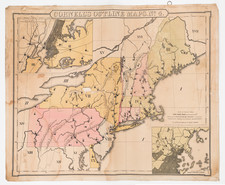
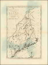
One of the earliest obtainable maps of the Province of Maine, as issued in the American Edition of Guthrie's Geography.
Includes towns, a road from Piscataqua Harbor top Pownalboro, rivers, mountaink,s etc. The Line between the US and British Possessions by Treaty of 1783 is shown.
Condition Description
Discoloration at centerfold and one minor spot.
Reference
Wheat & Brun 169.

![[New England] Tierra Nueva](https://storage.googleapis.com/raremaps/img/small/64626.jpg)