


|
||

|

|
|

|
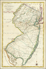
Nice early example of the first edition Mathew Carey's map of New Jersey, published in Carey's American Atlas in 1795.
The map provides topographical information and locates counties, the division between East and West Jersey, and many roads and towns. Shipman's Tvn is shown near Phillipsburg, with a road leading from Hiccory Tvn, to Bunnel's Tvn. The map was first advertised by Carey in 1794, but no separate issues have been located. Snyder notest that the map was an improvement over Faden's map in accuracy, showing counties and roads This is the first state of the map, distinguishable from the second state by the lack of the #32 in the upper right corner, which appears in later states.
Carey's American Atlas was the first atlas published in the United States, compiling a number of excellent maps from indigenous sources in the first compilation of American maps. This map was engraved by Samuel Lewis. An essential map for New Jersey collectors.
![Carte Particuliere de Virginie, Maryland, Pennsilvanie, La Nouvelle Jarsey. Orient et Occidentale [Heighten in Gold!]](https://storage.googleapis.com/raremaps/img/small/61392mp2.jpg)
![[Jefferson's Notes on the State of Virginia] Observations sur la Virginie [with the map:] A Map of the country between Albemarle Sound, and Lake Erie, comprehending the whole of Virginia, Maryland, Delaware, and Pensylvania, with parts of several other of the United States of America. Engraved for the Notes on Virginia.](https://storage.googleapis.com/raremaps/img/small/51828.jpg)