This item has been sold, but you can enter your email address to be notified if another example becomes available.


|
||

|

|
|

|
Stock# 20615
Description
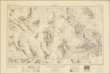
Interesting large format topographical map centered on Newport Beach, published by the United States Geological Survey.
The map extends from Santa Ana to Aliso Point, showing a number of Ranchos, including Santiago de Santa Ana, Loma de Santiago, and Las Bolsas. Includes early railroad lines, topogrphical details, towns, rivers, etc. One of the earliest detailed and reasonably obtainable maps of the region.
Condition Description
Dissected and laid on linen, with early manuscript annotations.
![[ Upper California, Texas and Mexico ] Carte Generale Du Mexique Ed Des Provinces-unies De L'Amerique Central ou Guatemala](https://storage.googleapis.com/raremaps/img/small/81604.jpg)
![[California Wine Advertising Graphic] Italian Swiss Colony Producers of Choicest California Wines Asti Colony Tipo](https://storage.googleapis.com/raremaps/img/small/83467.jpg)
![[Oregon / Mount Hood / Columbia River to Bodega Bay] Cote Nord-Ouest De L'Amerique Reconnue par Cape. Vancouver 2e. Partie . . .](https://storage.googleapis.com/raremaps/img/small/82223.jpg)