


|
||

|

|
|

|
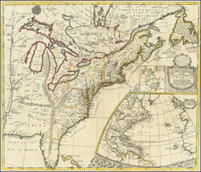
A fine large map of eastern North America west to the Mississippi River. Few English maps, based on English cartography show this entire region.
The English colonies are shown drawn on recent cartography such as the Hermann map of Virginia and Reed map of William Reed's manuscript map of New England, and the recent grants of Pennsylvania and West New Jersey. The map is a close copy of the Morden & Browne map of the same name, issued in 1695, which is a great rarity on the market. The map includes a wonderful treatment of the Great Lakes, a fascinating transcontinental mountain range from Michigan to Florida, wonderful depiction of the Mississippi River and terrific detail in the British Colonies. An inset map of Boston Harbor appears next to the title cartouche, above a large inset of the Atlantic Ocean and coasts of North America, Europe and part of Africa. Wonderful Florida projection.
John Senex (1678-1740) was one of the foremost mapmakers in England in the early eighteenth century. He was also a surveyor, globemaker, and geographer. As a young man, he was apprenticed to Robert Clavell, a bookseller. He worked with several mapmakers over the course of his career, including Jeremiah Seller and Charles Price. In 1728, Senex was elected as a Fellow of the Royal Society, a rarity for mapmakers. The Fellowship reflects his career-long association as engraver to the Society and publisher of maps by Edmund Halley, among other luminaries. He is best known for his English Atlas (1714), which remained in print until the 1760s. After his death in 1740 his widow, Mary, carried on the business until 1755. Thereafter, his stock was acquired by William Herbert and Robert Sayer (maps) and James Ferguson (globes).

![[ Carolinas & Georgia ] Virginiae Partis australis, et Floridae partis orientalis, interjacentiumqus regionum Nova Descriptio](https://storage.googleapis.com/raremaps/img/small/81554.jpg)