This item has been sold, but you can enter your email address to be notified if another example becomes available.


|
||

|

|
|

|
Stock# 19953
Description
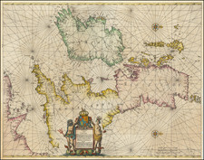
An attractive and rare chart of part of the southern coast of England, including Lizard Point, Plymouth, Torquay, Exeter, Dartmouth and Portland. In the very lower right corner the 'Kiscases' and 'Barroches' islands are marked. Includes the southern coast of Cornwall and Devon.
e map was initially engraved by Theunisz Jacobsz for his 1644 Lichtende Colomne, Ofte Zee Spiegel. This present example include the plate number W 12 and also the attribution By Jacob Theunisz Op't Water Inde Loots-man, making it an edition first published in 1666 by Caspar and Jacob Jacobsz's (who took the name Lootsman, to avoid confusion with their father.
Condition Description
Trimmed to neatline and mounted on larger sheet of 17th Century paper at an early date. Some soiling and discoloration in upper corners and along sides, likely the remnants of an early use at sea.
![(British Isles) Tabu Moder Anglie & Hiber [Modern Map of England and Ireland]](https://storage.googleapis.com/raremaps/img/small/103164.jpg)
![[Ancient Tribes of Great Britain and Roman Roads] Britannicae insulae, Tribus modis distinctae . . .](https://storage.googleapis.com/raremaps/img/small/77808.jpg)