|
||

|

|
|

|
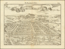
One of the Earliest Modern Plans of Buenos Aires Made by an Important Figure in the Independence Movement
Rare city plan of Buenos Aires produced by one of the early revolutionary governments of Argentina. It was made by the noted military engineer Pedro Antonio Cerviño, who was also an important figure in the political upheaval surrounding independence.
The Plan provides a detailed view of the city, including the urban grid. Near the harbor, the city blocks are filled in with development, but they give way to fields and open land farther inland. A key in the title block identifies 56 important sites within the city, with a 57th place name added in manuscript. There are several other blank spots in the list to encourage further amendments, an indication of the rapid growth of the city.
Highlights include the fort, now used as government offices (#1), which is situated near the port on the Rio de la Plata estuary. The Boca del Riachuelo (#56), which marks the limit of the Buenos Aires federal district, passes into the Rio de la Plata, while the old riverbed that had been blocked is also shown. Numerous mataderos, or slaughterhouses, are listed, and the Riachuelo is also known as the Rio Matanza, or Slaughter River. This reflects the importance of the cattle industry to Buenos Aires', and Argentina's, economy.
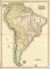
The Provincias Unidas del Rio de la Plata and Buenos Aires
A product of the Age of the Revolutions which shook the Atlantic World from 1776 to the 1820s, the Provincias Unidas replaced the government of the viceroyalty of Peru, which had been an administrative district of the Spanish Empire. It covered what is today Uruguay, and parts of Argentina and Bolivia.
In May of 1810, citizens of Buenos Aires rose up against the Spanish Viceroy and ousted him; this became known as the May Revolution. This began a 21 year period of conflict that saw different factions oppose each other as the modern state of Argentina emerged as an independent nation. In the early years, a Junta of representatives and later a triumvirate led government. The First Triumvirate ruled from September 1811 to October 1812.
On October 7, 1812, a military coup successfully overthrew the First Triumvirate, which was seen as too conservative by many of the people. Rather than seize power themselves, the military leaders called for a new election to create a Second Triumvirate. The newly elected leaders in turn called for an Assembly, the Assembly of Year XIII, which declared independence from Spain and wrote the first constitution. They also replaced the Second Triumvirate with the office of Supreme Director.
The Supreme Director was to serve as the executive officer of the United Provinces during a term of two years. The Director was to rule with a council of nine and would answer to a popularly elected congress. The Directorship lasted until 1820.
This plan was commissioned in 1814, during the tenure of the first Supreme Director, Gervasio Antonio de Posadas y Dávila, who served from January 31, 1814 to January 15, 1815. Posadas, a native of Buenos Aires, had also been a member of the Second Triumvirate and a drafter of the first constitution. After ceding power to the next Supreme Director, who was also his nephew, Posadas was jailed when his faction fell out of favor. He spent six years in 22 jails before being released in 1821.
Pedro Antonio Cerviño
Pedro Antonio Cerviño (1757-1816) was born in Spain. He joined the army and served in Buenos Aires from 1774 before returning to Spain to study at the Mathematics Academy in Barcelona. There he trained as a military engineer. He returned to Argentina in 1781 and later worked as part of the Brazilian Boundary Commission, that is as part of a group of engineers tasked to mark our the boundary between Spanish and Portuguese holdings in South America.
A year later, in 1782, Cerviño led an expedition to the Chaco in search of the metallic remnants of meteorites. Then, he served as an engineer to the military garrison in Buenos Aires. Next, he led another expedition to investigate the navigability of the Parana and Uruguay Rivers.
At the end of the eighteenth Century, Cerviño was commissioned by the Viceroy of Rio de la Plata to prepare a topographical map of Buenos Aires, the course of the Maldonado River, and the future town of Ensenada. It no doubt informed this later plan of the city. In 1798, he and two other engineers were commissioned to make a nautical chart of the Rio de la Plata.
Thanks to these varied experiences around the Viceroyalty, he was appointed as the first director of a nautical school which was founded in 1799 and closed in 1806. He was also active in the cultural life of the Buenos Aires; his house served as salon for savants and he published on matters topographical and nautical in the early newspapers of the nineteenth century.
Cerviño was key in fending off the two British invasions in the early 1800s and he supported the independence of the Provinces during the May Revolution in 1810. He was later placed in charge of the Academy of Mathematics and Nautical School.
In 1814, he substantially updated and refurbished his plan of Buenos Aires, and it became the first modern map of the city after Spanish Independence. It was made during a pivotal time in Argentinian history by one of the leaders of the revolution.
Rarity
The map is quite rare. OCLC locates no examples in participating institutional collections.