|
||

|

|
|

|
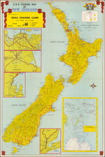
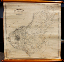
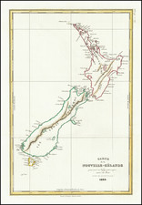
Important large format map of New Zealand, which incorporates the first major survey of the coast of New Zealand and updated details regarding the topography of the interior of the islands, with the original chart seller's plate on the verso (George T. Chapman of Auckland).
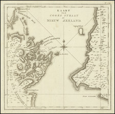
The first official survey of the New Zealand coastline was undertaken between1848 and 1855, under the direction of Captain J. Stokes of the Royal Navy (1848-1852) and Commander B. Drury (1852-1855). Prior to this date, the region had not been systematically charted since Captain James Cook's exploratory voyages. The present map incorporates the results of these surveys, as well as corrections published in 1858 and 1861 by J.D.Potter.
While early editions of the map published after 1861 included coastal detail, this later edition of 1872 is the earliest example we have located which includes significant detail in the interior parts. A comparison of this edition to the chart in the collection of the National Library of Australia shows (Map Rm 2213) shows extensive changes. The National Library of Australia also holds an example which is corrected to October 1872 (which is dated by NLA as 1874). The example we offer pre-dates the NLA 1874 edition, as it lacks the Oct 1872 notation and reflects that it is only updated to 1868.
The British Admiralty has produced nautical charts since 1795 under the auspices of the United Kingdom Hydrographic Office (HO). Its main task was to provide the Royal Navy with navigational products and service, but since 1821 it has also sold charts to the public.
In 1795, King George III appointed Alexander Dalrymple, a pedantic geographer, to consolidate, catalogue, and improve the Royal Navy’s charts. He produced the first chart as the Hydrographer to the Admiralty in 1802. Dalrymple, known for his sticky personality, served until his death in 1808, when he was succeeded by Captain Thomas Hurd. The HO has been run by naval officers ever since.
Hurd professionalized the office and increased its efficiency. He was succeeded by the Arctic explorer Captain William Parry in 1823. By 1825, the HO was offering over seven hundred charts and views for sale. Under Parry, the HO also began to participate in exploratory expeditions. The first was a joint French-Spanish-British trip to the South Atlantic, a voyage organized in part by the Royal Society of London.
In 1829, Rear-Admiral Sir Francis Beaufort was appointed Hydrographer Royal. Under his management, the HO introduced the wind force scale named for him, as well as began issuing official tide tables (1833). It was under Beaufort that HMS Beagle completed several surveying missions, including its most famous voyage commanded by Captain FitzRoy with Charles Darwin onboard. When Beaufort retired in 1855, the HO had nearly two thousand charts in its catalog.
Later in the nineteenth century, the HO supported the Challenger expedition, which is credited with helping to found the discipline of oceanography. The HO participated in the International Meridian Conference which decided on the Greenwich Meridian as the Prime Meridian. Regulation and standardization of oceanic and navigational measures continued into the twentieth century, with the HO participating at the first International Hydrographic Organization meeting in 1921.
During World War II, the HO chart making facility moved to Taunton, the first purpose-built building it ever inhabited. In 1953, the first purpose-built survey ship went to sea, the HMS Vidal. Today, there is an entire class of survey vessels that make up the Royal Navy’s Hydrographic Squadron. The HO began to computerize their charts in the late 1960s and early 1970s. In 1968, the compilation staff also came to Taunton, and the HO continues to work from there today.