|
||

|

|
|

|
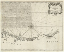
One of two maps of Southern Florida, which accompanied De Brahm's extremely rare Atlantic Pilot . . . published in London by T. Spilsbury in 1772.
The name Tequesta derives from the name of a Florida Indian Tribe which resided in the Miami-Dade County region, which had disappeared by the mid-18th Century. In 1513, Ponce de Leaon stopped at a bay in Florida called Cheqesta (now Biscayne) Bay. In 1565, Pedro Menendez de Aviles' fleet stopped in the bay near the main Tequesta village and traded with the natives, leaving with a nephew and brother of the chief who were taken to receive western education.
After the 1763 Treaty of Paris, the Brahm was appointed surveyor-general of the newly created Southern District of North America and surveyor of lands in the government of the newly formed royal colony of East Florida. On of his chief assistants in this new position was Bernard Romans. Samuel Holland was appointed surveyor-general to the Northern District. Florida was then virtually unknown to the British at that time.
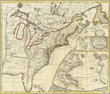
De Brahm's assignment was to map all the British Dominions South of the Potomac River. In early 1765, De Braham established his base of operations at Saint Augustine, Florida and began his major cartographic project-a survey of the coast from St. Augustine to the Cape of Florida.The making of the general surveys was carried forward amid several difficulties in the settled part of the interior of East Florida and on the east and west coasts of the province from 1765 to 1771. By 1771, the survey of the east coast had been completed, and the west coast had been surveyed from the tip of the peninsula as far north as the Bay of Tampa (Spiritu Santo). The St. Johns River was surveyed by water in 1766, and the environs of St. Augustine in the same year, as also the land from the capital across to Fort Picolata on the St. Johns. The land between St. Augustine and Cowford (Jacksonville), and between St. Augustine and the head of the St. Johns, was surveyed in 1768. Work was proceeding on the St. Marys River in 1770, when it was broken off because of sickness and the loss of an anchor.
De Brahm's work added substantially to an understanding and knowledge of the cartography and hydrography of the Florida region. During this same period, he acquired a grant of 10,000 acres in the province of Florida. It is also during this time that De Brahm produced his large map, printed by John Lewis and Samuel, Lewis, 1769, entitled A Plan of Part of the Coast of East Florida including St. Johns River. . . by William Gerard De Brahm. Unfortunately, De Brahm ran into difficulties and was summoned back to England.
While in England, De Brahm completed work on his mariner's guide, The Atlantic Pilot, which included two maps of Florida and a map of the Atlantic Ocean. Published in 1772, it was based in part on his extensive surveys of Georgia, South Carolina and Florida. The Atlantic Pilot is important both for its treatment and mapping of the region and its observations on the Gulf Stream. From the available records, the title "Gulf Stream" was first used to identify the flowing waters off the southeast coast of Florida in 1768 or 1769 by De Brahm. In 1771, he requested permission to publish the Atlantic Pilot, which he proposed as a description of the waters of eastern Florida for the benefit of all ships sailing in these dangerous waters. The Atlantic Pilot, together with its charts, described the "Gulf Stream" and its flows and eddies, based on the information which De Brahm derived from data he had collected as the Surveyor General of East Florida, and the Southern District. De Brahm's research predated Franklin's, though he is not generally considered to have "discovered" the Gulf Stream. One curious feature of the works is De Brahm's decision to ignore many earlier names appearing on Spanish charts. For example, De Brahm renames Biscayne Bay as Sandwich Bay, after the Earl of Sandwich.
![(Colonial East Florida / St. Augustine to Cape Canaveral area) -- [Land Holdings of John Moultrie, Deputy Governor of East Florida] A Schedule and apprasement [sic] of the property of John Moultrie in East Florida which he is now in possession of and did possess at the time that province was ceded to the crown of Spain](https://storage.googleapis.com/raremaps/img/small/86619.jpg)
![[French & Indian War] Carte Des Possessions Francoises et Angloises dans le Canada et Partie de la Louisiane . . . 1756](https://storage.googleapis.com/raremaps/img/small/94026.jpg)