This item has been sold, but you can enter your email address to be notified if another example becomes available.


|
||

|

|
|

|
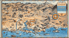
Stock# 1932
Description
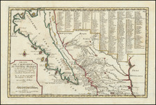
Highly detailed regional map of Southern California, extending from the Tehatchapi Mountains and Ft. Tejon in the Southwest, to Bakersfield and Kern Lake in the West, Lerdo and points north in the Northwest, Soldier's Well and Coyote Hole in the Northwest and Willow Springs, Mirage Plains and the Mohave Desert in the Southeast. Extremely detailed, including towns, wells, springs, rivers, mountains, railroad lines, hills, buttes, rocks, sinks, alkali flats, stage coach stations and many other features, plus agricultural notes. Minor fold breaks, else an excellent example.
![[ Earthquake Fault Lines ] Reconnaissance Map of the West Side of Sacramento Valley . . . 1920](https://storage.googleapis.com/raremaps/img/small/101680.jpg)