|
||

|

|
|

|
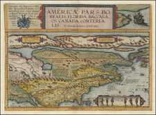
Ramusio's map of the Western Hemisphere is the earliest obtainable map to accurately depict the Americas. The map is attributed to Giacomo Gastaldi. It is the first map to depict the names derived from the travels of Francisco Vasquez Coronado in the Southwestern US, including Quivira, Sierra Nevadas, Cicuic, Axa, Cucho, Cibola and Tiguas. The reference to Sierra Nevadas derives from Cabrillo's explorations of the California Coastline in 1542. Wheat noted that Ramusio's map represented a significant advance in the mapping of the American West, calling it an advance of the first importance. The map reflects the lack of knowledge in the Northern parts of the Hemisphere, but does note the Strait of Magellan and retains the mythical large southern continent. The map also includes and early reference to Florida and depicts its peninsular shape, albeit oddly. An essential map for early American collections. Minor paper flaw in the margin, but otherwise an excellent example. Burden 24; 34; Wheat 9; Wagner 35.
Giovanni Battista Ramusio (1485-1557) was an Italian geographer who worked within the Venetian Empire. His father had been a magistrate and he himself served as a civil servant to Venice. He served throughout Europe, allowing him to build up a network of informants and a collection of travel materials. He compiled this information into his enduring masterpiece, Navigationi et Viaggi, in 1550 (first volume) and 1556 (third volume). The second volume appeared after his death in 1559, as the original manuscript had been destroyed by a fire.
![[ Aurora Borealis ] Karte der Geographischen Verbreitung des Nordlichtes. Von H. Fritz](https://storage.googleapis.com/raremaps/img/small/98483.jpg)