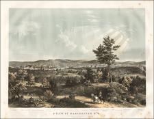


|
||

|

|
|

|
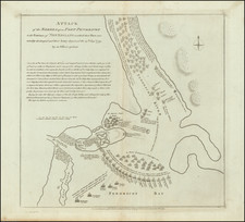
Interesting American battle plan, showing the action between the British and American Troops at the Battle of Penobscot, during the American Revolution.
In June-July 1779, a British expeditionary force of 3 ships and 700 men out of Halifax established Fort George at the entrance to the Penobscot River on the location of present-day Castine, in order to protect access to the valuable timber resources of Maine and establish a base from which to harass the Americans in northern New England. The Americans countered with a fleet of 40 ships and 2500 men from Boston, which was assembled by the Massachusetts government rather than the Continental Congress.
The Americans in fact met with initial success, forcing the British to reinforce with additional ships from New York. The Americans retreated up the Penobscot in disarray, where they ultimately were forced to scuttle those ships not captured by the British. According to a note on the plan, " The Rebels after destroying their shipping landed on [the southwest] side of the River and made the Best of their Way to Boston a distance of several hundred miles thro' Woods, Wilds, &c. Where many of them Perished."
The map provides an interesting account of the battle, but a very inaccurate location for Fort George, which is shown on an isthmus at the West side of the entrance to the Penobscot River, when in fact it was located farther out in the Bay to the East of the River.