


|
||

|

|
|

|
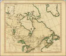
Fine example of Doncker's rare early map of the Northern part of America, including Hudson Bay, Davis Straits, Button Bay and the west coast of Greenland.
The map is similar to Lootsman's unrecorded map of ca 1670. The map covers the region bounded by Hudson Bay, Baffin Bay, Greenland and the Northern part of Newfoundland. Includes several notes concerning the explorations of Button, Hudson and Thomas Jacobus. Includes several tentative coastlines and several hopeful passages to the Pacific Ocean. The most notable difference is the correct spelling of Wales in New North Wales and New South Wales and the addition of an extensive pair of annotations at the bottom left and bottom center of the map, which provide detailed information on several English Voyages of discovery into the region.
The map covers the region bounded by Hudson Bay, Baffin Bay, Greenland and the Northern part of Newfoundland. Includes several notes concerning the explorations of Button, Hudson and Thomas Jacobus. Includes several tentative coastlines and several hopeful passages to the Pacific Ocean.
The Jacobsz/Lootsman family began with father Anthonie Jacobsz, who along with Blaeu and Colom were the most famous sea chart makers in Holland in the first part of the 17th Century. After Anthonie's death in 1643, his sons Caspar (born 1635) and Jacob continued the business after a period where their mother kept the business going until the sons came of age. Once the sons took over, they quickly changed their names to Lootsman, to avoid confusion with the father. Certainly by 1666, Caspar would have been old enough to have already engraved this map, there fore it is possible that this map actually pre-dates the work of Van Loon and Goos. While most of the body of work produced by the Lootsman bothers came in the 1670s, they are credited with work in the 1660s as well.
Regardless of the issue of primacy of the map sequence, the map represents an extraordinary find, being one of the few maps attributed solely to Caspar Lootsman and apparently an unrecorded example, which was not noted by Philip Burden in either of his books. Lootsman's charts are very rare on the market.
Hendrik Doncker was a prominent bookseller in Amsterdam best known for his sea charts and nautical atlases. He issued his own original charts, which he updated frequently, and also worked with colleagues like Pieter Goos, for example to produce the pilot guide, De Zeespeigel. He died in 1699, after fifty years in business. His plates then passed to Johannes van Keulen.

![[ Ottawa ] City of Ottawa Canada West](https://storage.googleapis.com/raremaps/img/small/74782.jpg)
![Carte Du Canada ou de la Nouvelle France et des Decouvertes qui y ont ete faites . . . [Map of Canada or New France and the Discoveries Made Therein . . .]](https://storage.googleapis.com/raremaps/img/small/94450.jpg)