|
||

|

|
|

|
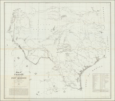
First edition, third issue of E.H. Ross' rare map of Texas, first issued in 1871.
In the history of Texas cartography certain landmark large-scale pocket maps come to mind, such as Austin's map of 1830, Hunt & Randel's map of 1839, and De Cordova's map of 1849. The present map stands in this same tradition, as do the maps of Roessler and Eppinger & Baker. Ross used Austin's map as the starting point for his format and created one of the earliest Texas maps designated as a railroad map. The map also shows early development of railroads in Indian Territory.
Includes an inset "Plan of the Western Part of Texas, and the cartouche features a vignette of a steam engine. In the left margin and adjacent portion of the map is some old ink writing of interest, "Report of the Texas Pacific R.R. Co. Nov. 23d 1875. Building Stone - fine magnesian limestone resembling that quarried at Caen, France, soft at first but hardens by exposure. Lead found in places on Grindstone Creek Parker Co. Gypsum found in the largest deposit known to exist in the world, in the NW part of the state of Texas."

![Mexique par Th. Duvotenay…1842 [Republic of Texas]](https://storage.googleapis.com/raremaps/img/small/93713.jpg)