The item illustrated and described below is sold, but we
have another example in stock. To view the example which
is currently being offered for sale, click the
"View Details" button below.


|
||

|

|
|

|
Stock# 18712
Description
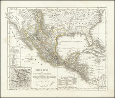
Fascinating map of the Southwest, at the time of Mexico's independence. California is dominated by pre-Fremont Cartographic features, including a mythical river extending toward Salt Lake. Lake Teguayo is shown, along with an are marked Freye Indianer. Dozens of notes on Indians throughout California, Arizona, Utah, Nevada and Colorado. Excellent details in the Rocky Mountains, based upon Humboldt, Pike and Fremont. Texas is named, but the map shortly predates Austin's Colony. Remarkably, Wheat overlooks this map entirely, although he does note the 1834 United States map. Remarkable early map of the southwest.
![[ Before The Salton Sea ] [ Official Map of San Diego County compiled from latest official maps of U.S. surveys, railroad and irrigation surveys, county records, and other reliable sources . . . Northeast Sheet ]](https://storage.googleapis.com/raremaps/img/small/101378.jpg)
![Central Route to the Pacific, From The Valley of the Mississippi To California. Journal of The Expedition of E.F. Beale, Superintendant of Indian Affairs In California, And Gwinn Harris Heap, From Missouri To California [with map:] Map of the Central Route from the Valley of the Mississippi to California](https://storage.googleapis.com/raremaps/img/small/99222.jpg)
![Mexican Painting. 3776 Codex Vaticanus page 74. Aglio 3rd Vol. called the Little Vatican MS. [on sheet with] Quetzalcoatl Crucified Codex Borgianus...](https://storage.googleapis.com/raremaps/img/small/102318.jpg)