|
||

|

|
|

|
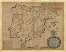
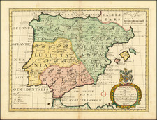
Fine old color example of Mercator's map of the Iberian Peninsula, from his Geographia.
Of all the editions of Ptolemy, Gerard Mercator's edition of 1578, is technically the finest (MapForum). Mercator's intention was to produce an atlas of the classical world, that would serve as a companion to his modern atlas, as one part of a description of the universe. Mercator attempted to return to the pure form of the original Ptolemaic atlas, discarding the modern information which was added during the prior 100 years to various printed editions of Ptolemy. As it happened, however, only the classical atlas appeared in Mercator's life-time. The atlas is, also, noteworthy for its longevity, the original printing plates were still in use in 1730, over one hundred and fifty years after they were first engraved.
Gerard Mercator is one of the most famous cartographers of all time. Mercator was born in Flanders and educated at the Catholic University in Leuven. After his graduation in 1532, Mercator worked with Gemma Frisius, a prominent mathematician, and Gaspar a Myrica, a goldsmith and engraver. Together, these men produced globes and scientific instruments, allowing Mercator to hone his skills.
With his wife, Barbara, Mercator had six children: Arnold, Emerentia, Dorothes, Bartholomeus, Rumold, and Catharina. In 1552, Mercator moved to Duisburg from Leuven, where he lived for the rest of his life. In 1564, he was appointed the official cosmographer to the court of Duke Wilhelm of Cleve.
Mercator’s most important contribution was the creation and popularization of a projection which now bears his name. On Mercator projection maps, all parallels and meridians are drawn at right angles to each other, with the distance between the parallels extending towards the poles. This allowed for accurate latitude and longitude calculation and also allowed navigational routes to be drawn using straight lines, a huge advantage for sailors as this allowed them to plot courses without constant recourse to adjusting compass readings.
Mercator’s other enduring contribution to cartography is the term “atlas”, which was first used to describe his collection of maps gathered in one volume. The Mercator atlas was published in 1595, a year after Mercator’s death, thanks to the work of his sons, particularly Rumold, and his grandsons.
![Mapa De los Obispados y Provincias antiguas de la iglesia de Espana en tiempo de los Godos [Map of the Bishoprics and Ancient Provinces of the Church of Spain during the Gothic Era]](https://storage.googleapis.com/raremaps/img/small/93479.jpg)