


|
||

|

|
|

|
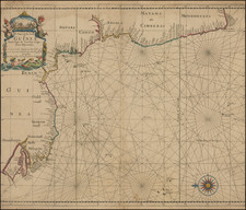
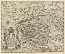
Rare Seller & Price sea chart of the west coast of Africa, from Cape Verde to the Cape of Good Hope.
The map appeared in an early edition of the first truly British sea atlas produced by John Seller, his partners and successors from the end of the 17th Century and updated and printed throughout the following one hundred years.
This rare English sea chart depicts the coast of Africa from Senegal all the way down to Cape Agulhas, past the Cape of Good Hope . The features of the coast are named in great detail, and the seas are elegantly traversed by loxodromes. The map is oriented with the east towards the top of the map. Decorative elements include a detailed cartouche of sea children, shells and a dolphin with a vignette of natives doing battle in the upper left corner and a compass rose in the lower right.
In 1671, London mapmaker John Seller (1630 - 1697) commenced work on English Pilot, a publication which he hoped would challenge the Dutch dominance of the market for sea charts and atlases. Seller envisioned a work in four books, covering different regions of the globe. Part I, describing northern navigation and published in 1671, was followed the next year by Part II covering southern navigation. In 1675 Part III, also known as Oriental Navigation, was printed though incomplete. Seller lacked the necessary capital to complete the mammoth undertaking, and in 1679 sold his rights to John Thornton (1641-1708), the official hydrographer to the English East India Company.
States of the Map and Rarity
There are 3 known states of the map:
- State 1 (1690): John Seller imprint. Includes a scale of miles and quarter compass rose.
- State 2 (1701): John Seller imprint. Scale of miles and quarter compass rose removed. Full compass rose at bottom right.
- State 3 (1734): Seller imprint removed from cartouche.
This edition of the map is drawn by Jeremiah Seller (1675-1720), John's son, from the incomplete English Pilot, Part III of 1675 . Jeremiah Seller apprenticed under his father and was a mapmaker, instrument-maker and publisher. The younger Seller and his partner, Charles Price, were "Hydrographers to ye Queen" and "Compass makers to the Navy Royall." In partnership with Price, Jeremiah issued The Fifth Part of the General English Pilot … West Coast of Africa … By Jer. Seller and Cha. Price London Printed by J. Mathews … at the hermitage Stairs in Wapping. in 1701, from which this map hails.
Circa 1705, complaints over the quality of their instruments caused Seller and Price to lose their contract with the Admiralty and, like his father before him, the firm was forced into bankruptcy. Despite the family's financial difficulties, English Pilot succeeded in giving the British dominance in the sea chart market as the 18th Century progressed.
This map is rare, with only one example offered in a dealer catalogue in the past 25 years (Susannah Fisher, Catalogue 58, 1988).
Cf. Phillips, Atlases, 4278-10.
Tooley, African Continent, p. 101-7.
Tooley, Map-Makers, p. 60-4.
Verner & Skelton (eds.), John Thornton - The English Pilot: The Third Book (Facsimile 1703 edition).
Charles Price (1679?-1733) was an engraver, instrument maker, and mapseller.
Price had been apprenticed to John Seller, famous mapmaker and father to Charles’ business partner, Jeremiah. In fact, Jeremiah and Charles were made free of the Merchant Taylors Guild on the same day, September 1, 1703. The two were already working together by then.
After breaking off with Seller, Price worked with John Senex (1705-10) and George Wildey (1710-13). He was still working in the 1720s, but was in Fleet Prison in 1731 for debt and died two years later.
Jeremiah Seller (1671-?) was the second son of prominent London mapmaker John Seller. He inherited two-thirds of the business upon his father’s death in 1697. From 1700-5 Seller worked in partnership with Charles Price. In 1705, Jeremiah lost the family contract to supply instruments to the Royal Navy, which led to the dissolution of his partnership with Price. Seller left the map trade in that year, passing his stock to Richard Mount and Thomas Page.
![[Belgian Congo - Katanga ]](https://storage.googleapis.com/raremaps/img/small/99902.jpg)
![[Northern Nigeria Protectorate]](https://storage.googleapis.com/raremaps/img/small/70705.jpg)