The item illustrated and described below is sold, but we
have another example in stock. To view the example which
is currently being offered for sale, click the
"View Details" button below.


|
||

|

|
|

|
Stock# 1857
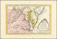
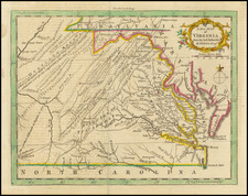
Description
An attractive and scarce map of Virginia and West Virginia as far as 82 degrees west longitutde. On the Middle Fork of the Holston River near Abingdon is the farm of S. Stahlmaker and in West Virginia at the junction of the Green Briar and New Rivers is the homestead of J. Keeny's. These are described as the farthest western settlements in Virginia in 1755. In the Appalachians are a Cow Pasture, Calf Pasture and Virginia Boundary with ye Six Nations in 1722. A number of early Indian Tribes and place names are located. An excellent early map of colonial Virginia. Jolly Lond-205.