


|
||

|

|
|

|
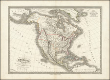
Striking Italian Map of the Americas and the Pacific Ocean, tracing the voyage of Captain James Cook through New Zealand and the South Pacific and illustrating some of the great cartographic myths and inaccuracies of the late 18th Century.
The map shows several unusual projections of the Northwest Passage, based upon reports from the Russian explorations recently published in the Royal Academy of Sciences in Paris, although not consistent with the reports of J.N. De L'Isle. North America is projected far too wide, with a number of long rivers extending from the Oregon and Washington coasts to nearly the Mississippi. Salt Lake (Lago Salado) appears in the central continent, due to the miss-projection of the western coast. Indian tribes and native villages are noted in North and South America. New Zealand and the tracks of Cook's voyage of 1768-71 are noted, including Cook's navigation between the major islands of New Zealand.
The map includes the notation of a Chinese colony, "Fou-Sang," based upon Hui Shen's supposed voyage of 499 AD, in the area which would roughly be Puget Sound. This is one of the few maps which notes the supposed Chinese contact with the west coast of North America, which is reported upon in a number of generally discredited sources (most recently Menzies' 1421). According to Suarez, such mappings of the ancient Chinese colony reflect the whims of data-hungry 18th Century mapmakers.
As with many maps by Zatta, the decorative title vignette dominates the lower right corner. The pictorial cartouche shows a lion sleeping among flora.
Antonio Zatta was a leading European cartographer and publisher, and his
Atlante Novissimo (Venice, 1775-1785) was one of the most beautifully produced of all 18th Century atlases, with much space devoted to the new discoveries of Captain Cook. This map was issued as part of Zatta's monumental four volume
Atlante Novissimo which contained 218 maps. Along with his contemporary, Giovanni Battista Pasquali, Zatta was responsible for the revival of taste in Venetian fine printing. Famous for his sardonic tone and as something of a controversialist, he was also well known for producing lavish editions of Italian classics and raccolte (collections of poems for special occasions).
Zatta's map is one of the better examples of 18th Century speculative cartography, making it one of the most sought after regional maps of the period and without doubt the most decorative. A gorgeous color example of both cartographic myth and the concrete voyages of Captain Cook.
Antonio Zatta (fl. 1757-1797) was a prominent Italian editor, cartographer, and publisher. Little is known about his life beyond his many surviving published works. It is possible that he was born as early as 1722 and lived as late as 1804. He lived in Venice and his work flourished between 1757 and 1797. He is best known for his atlas, Atlante Novissimo (1779-1785), and for his prolific output of prints and books that were both precisely made and aesthetically pleasing. Zatta clearly had a large network from which to draw information; this is how he was able to publish the first glimpse of the islands visited by Captain Cook in the Atlante Novissimo. Zatta also published books of plays and architecture.

![[Nome Gold Rush] Map of Seward Peninsula The Arctic Gold Fields of Alaska Showing Precinct Boundaries, Recording Offices, Post Offices, Trails & Road Houses . . . December 1903](https://storage.googleapis.com/raremaps/img/small/76156.jpg)
![L'Amerique Septentrionale qui fait partie des Indes Occidentales... [with] Description Abrege de L'Amerique Septentrionale](https://storage.googleapis.com/raremaps/img/small/99762.jpg)