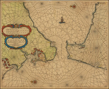
![[Basque Coast] Die Zee Custen van Biscaijen tuschen Laredo en Sentillana soe hem dat Selue landt all daer vertthoornt enn opdoet . . . 1583 By Lucas Janszoon Waghenaer](https://storage.googleapis.com/raremaps/img/small/61468.jpg)


|
||

|

|
|

|
Striking full color example of Wagenhaer's map of the northwestern coast of Spain, from Lhanes to Laredo.
Includes 2 sea monsters, 2 sailing ships, a compass rose, and 2 decorative cartouche, soundings, and anchorages. Profiles of the Coast near are shown.
Wagenhaer was a Dutch pilot who produced the first set of effective navigational charts, under the title Spiegel der Zeevaerdt. These gorgeous charts, engraved by Baptist and Jan van Doetecum, embody the latest contemporary knowledge of navigation and position finding and set the standard which was followed for more than a century. Waghenaer's charts are magnificent works of art, which are highly sought after by collectors. An essential map for collectors of the region and the earliest decorative sea chart of the region. Nice old color example. Minor soiling.
![Regnorum Hispaniae et Portugalliae Tabula Generalis jam nuper edita . . . [includes Balearic Islands]](https://storage.googleapis.com/raremaps/img/small/79438.jpg)