|
||

|

|
|

|
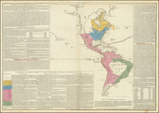
Rare map of America and the discoveries in the Pacific Ocean, published by Eustace Herisson and corrected by Basset. The focal point of the map is the 3 voyages of Cook, which are tracked on a periodic basis through the Atlantic, past Tierra del Fuego and into the Pacific (and touching on Cape Horn), during 1768-1779. The periodic dates primarily focus on land falls and other dates noted in the explorers diaries. The tracks reach New Zealand, the New Hebrides and the various islands of the South Pacific, as well as Cook's track through Hawaii and along the West Coast of the US. Despite the title, this is a fine map of the South Pacific. The treatment of America proper is large and well defined, reflecting a time period immediately after Vancouver, Lewis & Clark, Pike, Humboldt and Stephen Long, when the mapping of the American West and the Pacific NW was very much in flux. The treatment of the NW region, including Canada, Russian Territory and the NW Passage are notable. Vancouver and MacKenzie's discoveries are prominent in these regions, as are notes regarding Hearn and others. A rare large format map, with no examples appearing in dealer catalogues over the past 20 years. The map was likely issued separately and periodically bound in to oversized custom atlases. A worthwhile map for Pacific and NW Collectors.
![[ First State of the First Map of America ] Novae Insulae XVII Nova Tabula](https://storage.googleapis.com/raremaps/img/small/94609.jpg)