|
||

|

|
|

|
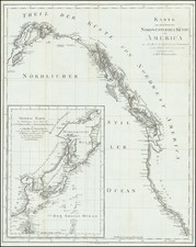
Fine example of the 1848 (our dating) edition of Wyld's massive map of North America, which includes the extra panel at the bottom, adding Central America, first issued in 1824.
John Wyld was one of the most prolific publishers of separately issued maps during the 19th Century. His 6 (and later 7) sheet map of North America is a testament to Wyld's publishing accumen. First published in 1823, the map was periodically updated to incorporate new discoveries. However, Wyld had the curious habit of frequently leaving older information on the map, making for a very curious mix of geographical details.
The evolution of Wyld's map of North America is truly fascinating, and reflects Wyld's commercial savy. The map was periodically updated in the 1820 and 1830s. With the outbreak of the Mexican-American War in 1846, Wyld issued a special 4-sheet edition of the map (eliminating the top 2 sheets and the bottom central America sheet), with a new title ( Mexico the British Possessions in North America and the United States . . . 1846), which included a number of geographical revisions in the regions depicted and focused on the battlegrounds of the Mexican American War. Following the resolution of the Mexican-American War, Wyld re-issued his map of North America, showing the boundaries as established by the Treaty of Guadalupe Hidalgo, and with significant updates in the polar region, Alaska and northern Canada.
In 1849, with the discovery of Gold In California, Wyld again saw commercial opportunity. Wyld again issued a section of his 7-sheet map of North America, under the title The United States Of North America With Part of the British Possessions And Mexico . . . 1849 . For this map, Wyld completely re-worked California and incorporated for the first time the information from John Fremont's seminal map of Oregon and Upper California. The following year, Wyld would again release a revised edition of his 7 sheet map of North America, retaining the changes made in the US Gold Rush map of 1849, but with additional updates in both the US and again in the northern sections of the larger North America map which had not been offered as part of the US Gold Rush map of 1849.
While we have not attempted a complete cataloguing of all of the later editions, we note that Wyld issued editions of his map of North America in 1860 and again in 1875. We suspect, although we have not made the analysis, that some of the Civil War maps issued by Wyld during the early 1860s are probably again fragments of his larger map of North America.
This undated edition, which we have dated 1848 because of its relationship to the1846 4-sheet map of Mexico . . . and the 1849 US Gold Rush Map, has been significantly updated from the 1838 edition. Among the more noteworthy additions are as follows:
North West Sheet: The northern coastline of Alaska is now complete, most notably along the area labled West Georgia, which was left blank in the 1838 edition. The coastline and cape to the west of this area has also been significantly revised. The beginnings of a river system in southern Alaska are now shown, whereas the 1838 edition had no rivers. Nunivak Island appears for the first time, as does the large Kuskokwim River and the large bay which if forms just to the south. A number of bays and rivers in the western part of Alaska also appear for the first time. In Canada, east of Queen Charlotte's Island, a number of rivers appear for the first time in an area which had largely been blank in the 1838 edition and several mountain ranges show minor changes. Along the Northwest Passage, there is new detail around the area of Victoria Island and the Coronation Gulf, which is beginning to show the first details of a Dolphin and Union Strait and the southern coastline of the lands to the north.
North East Sheet: Most of the changes are in the area west of Baffin Bay near Lancaster Sound and Admiralty Inlet, where there is significantly more coastal detail than in the 1838 edtion and the shap of Admiralty Inlet and its southern most coastline have been radically altered.
Central West Sheet: Significant updates have been made to the river systems in the western part of Canada and the mountains west of the Canadian Rockies have been revised. The tentative dotted line boundary of between the US and Canada has been replaced with an accurate depiction of the border. The river systerms in Western Oregon have been improved and the number of placenames on the coastline has doubled. The western part ofCanadian Rockies includes signficiantly new mountain details and some new lake and river details. In the Interior of the Northwestern US, there are additional placenames along a number of rivers.
Central East Sheet: No major changes:
South West Sheet: The boundary between Mexico and the US has been revised to reflect the Treaty of Guadalupe Hidalgo, making Upper California, New Mexico and Texas part of the US, however the border slopes northward to San Diego Bay, several miles north of its present location. A large river running south from San Francisco Bay for nearly two thirds of California has been added with a large lake in the middle, approximating the San Joaquin Valley and several smaller rivers have been added in Southern California. California includes more Indian Place names.
South East Sheet: Many new place names in the Southeastern US, most notably in Southern Georgia. Arkansas is no longer running across the top of Texas in its "double-wide" configuration, but the boundary is shown 1 degree east of its proper location. Missouri has been enlarged in the north, but is also too narrow, losing 1 degree in the west. Many new place names in Texas and Arkansas. Several new placenames appear along the Gulf Coast on the Texas and Louisiana Coast lines and the shape and angle of the coastline has been changed just below the Rio Grande in northern Mexico. Several new roads in Texas and a few new rivers.
Central America Sheet: New placenames on the north coast. New political borders in Central America. Changed place names in the Yucatan.
Rumsey notes:
The first edition, listed in Phillips but not by Stevens and Tree or Wheat [was published in 1823] . . . A large impressive map showing with great accuracy the recent discoveries in the north west passage, but wildly off in the American southwest - Wheat: "a large and beautiful map, excellent in all respects save for its southwestern geography." In the southwest, Wyld adds many mountain ranges that were purely speculative - probably just to fill in blank spaces in the map (unlike Arrowsmith). In northwestern Texas is a curious note on the topography of the area attributed to "Mellish" which is copied from a pre-1822 edition of his large map of the United States. Comparing this edition to the derived map of 1846, "Mexico, the British Possessions...," ; one sees many changes in the northern areas and few in the southwest. Stevens and Tree list editions of 1824, 1827/8, 1838, and 1851/56.
In addition to the editions listed by Rumsey, we note edtions identified by OCLC as havng been published in 1854, in the 1860 and "1870s." The Rumsey collection also includes an 1875 edition of the map.
In December 2000, Sotheby's offered a map which would appear to be a Faden edition of this map, dated 1820 and described as follows:
North America-Faden, W. Map of North America from 20 degrees to 80 degrees north latitude exhibiting the recent discoveries, geographical and nautical. London: Willam Faden, 1820
Total dimensions if joined 1480 x 1650mm., large engraved wall-map in 6 sheets, original outline colour . . .
Extremely detailed map of North America, incorporating the discoveries of explorers such as Pike, Humboldt, Lewis and Clark, Mackenzie, Ross and Vancouver. Within Arctic Canada are pencil additions, supplying a northern coast for Alaska and additional information for the region between Baffin's Bay and Hudson's Bay, the latter additions in German.
Full Title: Map of North America Exhibiting The recent Discoveries, Geographical and Nautical; Drawn Chiefly from the Authorities of M. De. Humboldt, Lieutt. Pike, Messrs. Lewis and Clarke, Sir. Alexandr. MacKenzie, Mr. Hearne, Coll. Bouchette, Captns, Vancouver, Ross, Parry, Franklin & Back, also describing the Boundary Lines between the Territories of Great Britain, the United States, and the Mexican and Central States -- London Published forJa. Wyld, successor to W. Faden. No. 5 Charring Cross. Geographer to His Majesty.
James Wyld Sr. (1790-1836) was a British cartographer and one of Europe’s leading mapmakers. He made many contributions to cartography, including the introduction of lithography into map printing in 1812.
William Faden, another celebrated cartographer, passed down his mapmaking business to Wyld in 1823. The quality and quantity of Faden’s maps, combined with Wyld’s considerable skill, brought Wyld great prestige.
Wyld was named geographer to Kings George IV and William IV, as well as HRH the Duke of York. In 1825, he was elected an Associate of the Institution of Civil Engineers. He was one of the founding members of the Royal Geographical Society in 1830. Also in 1830, his son, James Wyld Jr., took over his publishing house. Wyld Sr. died of overwork on October 14, 1836.
James Wyld Jr. (1812-87) was a renowned cartographer in his own right and he successfully carried on his father’s business. He gained the title of Geographer to the Queen and H.R.H. Prince Albert. Punch (1850) described him in humorous cartographic terms, “If Mr. Wyld’s brain should be ever discovered (we will be bound he has a Map of it inside his hat), we should like to have a peep at it, for we have a suspicion that the two hemispheres must be printed, varnished, and glazed, exactly like a pair of globes.”
![[Route of the 1938 Westward Northwest Passage Cover] Map of the Northwest Territories 1929](https://storage.googleapis.com/raremaps/img/small/60046.jpg)
![A Map of North America, Constructed According To The Latest Information: by H.S. Tanner. Improved to 1825 [Case Map]](https://storage.googleapis.com/raremaps/img/small/68580.jpg)