


|
||

|

|
|

|
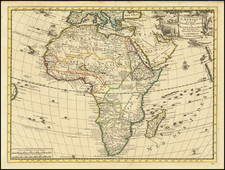
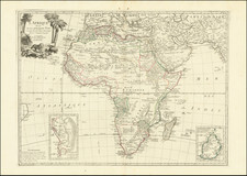
Scarce, early decorative map of Africa published by Carol Allard, based on De Wit's map of Africa c.1670.
The present edition is the second state of the map, with changes in the decorative cartouche and title image. Climate notations in the latitude gridlines on the left and right have been added, as well as some minor differences in the body of the map, including an addition of a road or boundary in Abyssinia.
This map is similar to the De Wit's Africa in its later states and even uses some of De Wit's lettering within the surrounding gridline. However, while the map shows many fictitious cartographic details, particularly in the south, Allard updated the geography of the interior. This example depicts two Ptolemaic lakes in Central Africa and the source for the Blue Nile at Lake Tana in Abyssinia is well developed. These details suggest French influences (Duval, De Fer and others) in the development of this map.
The cartouche is attractively African in style and content. An elaborate vignette surrounding the title contains a woman as an allegorical representation of Africa, along with two children, an ostrich, a lion, and a crocodile.
There is also wear to the palm trees and a camel behind the crocodile's tail at the right of the vignette. While both states have these figures, they must have been lightly etched in the first state, resulting in their obvious wear as seen here in the second state.
Carol Allard (1648-1706) was the son of Hugo Allard who founded a map publishing house in Amsterdam. Carol produced an Atlas Minor in 1694, an Atlas Major c. 1765 and a hundred-plate Orbis habitabilis oppida in 1698. The Allard's publishing trade was passed to the third generation, Carol's son Abraham, in 1706.
Nice full color example of this fine decorative map.
Carel (Carol) Allard (Allardt) (1648–1709) was an engraver and publisher based in Amsterdam. Part of a prominent family of Dutch mapmakers, publishers, and print sellers, his father was engraver and publisher Hugo Allard (1627–1684), who left his business to Carel upon his death. Carel published anything in demand, including maps, topography, ethnography, newsprints, and restrikes of old plates of artistic prints, many of which likely came from his father’s stock. In 1706, Carel gave his copperplates to his son Abraham Allard, before going bankrupt.
![[Wall Map of Africa] L'Afrique Divisee en ses Principales Parties et ses Isles Tire des Relations les plus Recentes . . . 1782](https://storage.googleapis.com/raremaps/img/small/91459.jpg)