


|
||

|

|
|

|
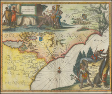
First state of this scarce and detailed map of the area around Charleston, South Carolina (founded 1669), based upon the surveys and manuscript maps of Maurice Mathews and an extremely rare map of South Carolina by Thornton and Morden, published ca. 1695 and is widely regarded as the first obtainable map of the region around Charleston to appear in a Commercial Atlas.
The map extends from the Edisto River in the South to the Sewee and Santee Rivers in the North, cetnered on Charles Town and the Cooper River. While the title is in French, the map includes the names of dozens of early landowners around Charleston and along the coastline and the major rivers, extending far up the Ashley and Cooper Rivers, Goos Creek, Edisto River and Wando River. At the northernmost point on the Cooper River, the Santee Indian Fort, Faralaunes, and the Colleton's Barony are shown. Sir John Colleton (1608-1666) lost most of his property to the forces of Parliament, but was later knighted by Charles II, upon restoration of the Stuart Monarchy. He was a member of the Council for Foreign Plantations and of the Royal African Company which introduced slavery into British possessions in North America. He was one of the 8 proprietors of the Carolina grant and actively interested in its sucess, although he died relatively shortly after its creation in 1665.
The map also notes a number of Indian Settlements and shows the early roads in the region. A marvelous example, in original color. First state, lacking the plate number which distinguishes the 2nd state from the first. One thin spot where the word Great in Great Savannah appears, likely caused by the professional removal of an old library stamp. An essential map for South Carolina Collectors.
Pierre, or Pieter, Mortier (1661-1711) was a Dutch engraver, son of a French refugee. He was born in Leiden. In 1690 he was granted a privilege to publish French maps in Dutch lands. In 1693 he released the first and accompanying volume of the Neptune Francois. The third followed in 1700. His son, Cornelis (1699-1783), would partner with Johannes Covens I, creating one of the most important map publishing companies of the eighteenth century.
![Carte De La Louisiane Et Du Cours Du Mississipi . . . Juin 1718 [1st State!]](https://storage.googleapis.com/raremaps/img/small/59797.jpg)
![Dominia Anglorum in America Septentrionali Specialibus Mappis Londini primum a Mollio… [4 maps--New England; Chesapeake, Georgia, Carolinas & Florida; and Nova Scotia…]](https://storage.googleapis.com/raremaps/img/small/60331.jpg)


