The item illustrated and described below is sold, but we
have another example in stock. To view the example which
is currently being offered for sale, click the
"View Details" button below.
![[ Southern Ukraine / Mykolaiv Oblast / Kherson ] Die Otschakowische Tartarey Oder Westliches Nogaj Auc Jedistan By Franz Johann Joseph von Reilly](https://storage.googleapis.com/raremaps/img/small/102019.jpg)
1794 Franz Johann Joseph von Reilly
$ 225.00


|
||

|

|
|

|
Stock# 16880
Description
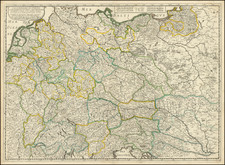
Very scarce regional map of the region at the north end of the Black Sea, between the Bug and the Dniestr River.
Shows rivers, roads, towns, castles, forests, lakes and a host of other details. Quite possibly the most detailed map of this region to appear in an 18th Century Atlas. From Von Reilly's exceedingly scarce Grosser Deutscher Atlas.
Von Reilley & Schraembl led a revival of map making in Vienna in the late 18th Century which included this and several other sought after works.

![[ Marshal Oudinot Copy ] Landes-Grenze zwischen dem Königreich Preussen und dem Herzogthum Warschau nach der am 10ten November 1807, dem Tilsiter Friedens Tractat vom 9ten Juli 1807 gemäss, zu Elbing abgeschlossenen Convention und der im Jahre 1808 darauf erfolgten örtlichen Begrenzung, als Supplement, der von Schröttersche](https://storage.googleapis.com/raremaps/img/small/99041.jpg)