This item has been sold, but you can enter your email address to be notified if another example becomes available.


|
||

|

|
|

|
Stock# 16687
Description
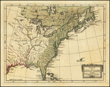
Detailed map of the United States, including Upper California and Texas. Highly detailed. Shown the railroad lines in the Eastern United States. Fascinating printing technique, involving mulitple colors, likely from different impressions. For example, Santa Fe, San Antonio, Astoria, Little Rock and New Orleans are all printed in red, as are most of the railroad towns and railway lines. Nice detail in the Rocky Mountains and Oregon Territory. Excellent detail of the Indian Tribes and Districts and a number of the early American and Canadian Forts. Fine example with decorative border.
![Trails: [1595-1945]: Land, Sea, and Air of The American Adventure Series](https://storage.googleapis.com/raremaps/img/small/70672.jpg)
![Map of the United States And Territories, Together with Canada &c. [Shows Massive Idaho Territory]](https://storage.googleapis.com/raremaps/img/small/100353.jpg)