


|
||

|

|
|

|
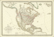
The true first edition of Brue's map of Map of North America, known to Wheat only by the later 1825 edition (Wheat 335). The map is a marvelous post-Lewis & Clark production, combining excellent detail from the expedition in the Northwest with information from Pike, Humboldt and others. The Phillipe ou Rio del Colorado flows from Monterey to Both Lake Teguayo and Timpanago and then onward even further toward the Rocky Mountains. Excellent detail in Texas. Double wide Arkansas Territory. Remarkable Indian details. The Missions of Upper California are named. Single Cordillera, as described by Humboldt. Excellent detail in Western Canada and Russian America. The first edition of this map is rare on the market, with no example being offered in a dealer catalogue in over 10 years. The map was apparently folded down into a smaller folio atlas, but is generally in excellent condition.
Andre Hubert Brué was a French geographer and cartographer. Born in Paris, he served in the French Navy, joining the Baudin expedition to the Pacific (1800-1804). After his sea service, Brué applied his navigation and charting skills to creating finely-crafted maps, which were renowned for their crisp engraving and accuracy. He drew directly on the copper of the plate, creating what he called encyprotypes. He is best known for the Atlas universal de géographie physique, politique, ancienne et moderne.

![[ Sea of the West ] L'Amerique Septentrionale divisee en ses principaux Etats . . . 1782](https://storage.googleapis.com/raremaps/img/small/80228.jpg)
![[Pan American Menu Map] North America](https://storage.googleapis.com/raremaps/img/small/103976.jpg)
![[ British Colonies in North America & Caribbean ] L'Amerique Angloise, ou Description des Isles et Terres du Roi d'Angleterre dans l'Amerique, Avec de nouvelles Carte de chaque Isle & Terres](https://storage.googleapis.com/raremaps/img/small/102812.jpg)