|
||

|

|
|

|
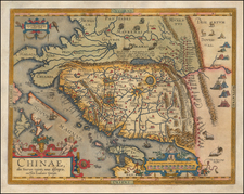
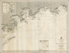
Striking map of China, Japan, Korea and the Northwest Coast of America.
Shows the Great Wall, Korea as an Island and a badly misprojected Japan. The annotations beneath the land sailing craft suggest that this is an indigenous mode of transportation. On the Northwest Coast of America, the annotation references the Tartar hordes which inhabit the region and names Cape Fortuna, Anconde Island, Costa de los Tacbaios, Costa Brava and Alcones. Interesting depiction of eastern and western sailing craft, a sea monster and other decorative and fanciful features. One of the most sought after maps of China.
Jodocus Hondius the Elder (1563-1612), or Joost de Hondt, was one of the most prominent geographers and engravers of his time. His work did much to establish Amsterdam as the center of cartographic publishing in the seventeenth century. Born in Wakken but raised in Ghent, the young Jodocus worked as an engraver, instrument maker, and globe maker.
Hondius moved to London in 1584, fleeing religious persecution in Flanders. There, he worked for Richard Hakluyt and Edward Wright, among others. Hondius also engraved the globe gores for Emery Molyneux’s pair of globes in 1592; Wright plotted the coastlines. His engraving and nautical painting skills introduced him to an elite group of geographic knowledge seekers and producers, including the navigators Drake, Thomas Cavendish, and Walter Raleigh, as well as engravers like Theodor De Bry and Augustine Ryther. This network gave Hondius access to manuscript charts and descriptions which he then translated into engraved maps.
In 1593 Hondius returned to Amsterdam, where he lived for the rest of his life. Hondius worked in partnership with Cornelis Claesz, a publisher, and maintained his ties to contacts in Europe and England. For example, from 1605 to 1610, Hondius engraved the plates for John Speed’s Theatre of the Empire of Great Britaine.
One of Hondius’ most successful commercial ventures was the reprinting of Mercator’s atlas. When he acquired the Mercator plates, he added 36 maps, many engraved by him, and released the atlas under Mercator’s name, helping to solidify Mercator’s reputation posthumously. Hondius died in 1612, at only 48 years of age, after which time his son of the same name and another son, Henricus, took over the business, including the reissuing of the Mercator atlas. After 1633, Hondius the Elder’s son-in-law, Johannes Janssonius, was also listed as a co-publisher for the atlas.