


|
||

|

|
|

|
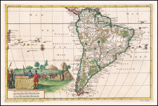
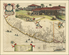
Gorgeous full color example of this regional map of Brazil, first printed for C.Barlaeus. This map is one the first maps of Brazil based on Dutch rather than Portuguese interest. The Dutch West India Company, appointed Count Johan Maurits Governor-General of Dutch Brazil in 1636 and was in power until 1644. Upon Maurits return to Europe, he commissioned Kaspar van Baerle to document the flora and fauna, climate, inhabitants, religion, and languages of the coastal provinces of Brazil. The resulting work, Rerum per octennium in Brasilia published by Blaeu, is one of the finest works of Brazil ever produced. The maps in this work, with alterations, later appeared in later editions Blaeu's Atlas Major and composite atlases by Mortier. This detailed map is highly embellished with cartouches, coats of arms, ships and a sea battle. The large scene on the upper quarter of the map depicts the commercially important sugar cane industry. A scarce, important and quite beautiful map. Minor reinforcement to centerfold and two short marginal tears, else a nice example.
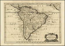
Pierre, or Pieter, Mortier (1661-1711) was a Dutch engraver, son of a French refugee. He was born in Leiden. In 1690 he was granted a privilege to publish French maps in Dutch lands. In 1693 he released the first and accompanying volume of the Neptune Francois. The third followed in 1700. His son, Cornelis (1699-1783), would partner with Johannes Covens I, creating one of the most important map publishing companies of the eighteenth century.