


|
||

|

|
|

|
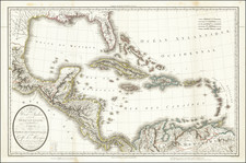
Rare separately issued French edition of the first edition of Thomas Jefferys map of Florida and the Gulf Coast, which also appeared in the very rare Le Rouge's Atlas Ameriquain Septentrional.
The map was one of the earliest large format French maps to treat the region with such remarkable detail, including soundings and rhumblines. The map follows the first edition of Jeffery's map, which was significantly revised in a second edition of 1775. The detail in Florida and the Bahamas is excellent as is the elaborate compass rose and sailing ships.
While the Jefferys edition of this map appears on the market with some frequency, this is the first example of this map we have seen on the market in more than 10 years and the first separately issued example we have ever seen.
![[ Pictish Warrior Woman ] Feminae Pictae icon V](https://storage.googleapis.com/raremaps/img/small/99648.jpg)
![Colton's West Indies [Bermuda and Havana insets]](https://storage.googleapis.com/raremaps/img/small/71868.jpg)