This item has been sold, but you can enter your email address to be notified if another example becomes available.


|
||

|

|
|

|
Stock# 15393
Description
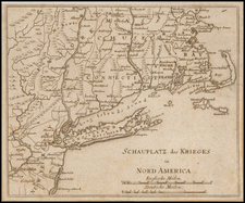
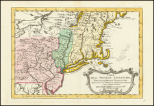
Rare early map of the region bounded by New England, Lake Ontario and the northern Chesapeake River, centered on New York and Connecticut from Bellin's Histoire Generale des Voyages. Shows towns, roads, mountains, rivers, islands, capes, ports and other nice details. A nice French & Indian War map of the Northern British Colonies. Nice wide margined example in attractive wash colors. While similar to Bellin's map, New York is spelled differently and the map includes different information.
![[British Colonies in America] Carte Qui Contient Une Description Des Iles & Terres Que Les Anglois . . .[maps of Chesapeake, Carolinas, New England, Bermuda, Gulf Coast, Jamaica, Barbadoes & Canada]](https://storage.googleapis.com/raremaps/img/small/61480.jpg)