The item illustrated and described below is sold, but we
have another example in stock. To view the example which
is currently being offered for sale, click the
"View Details" button below.


|
||

|

|
|

|
Stock# 15042
Description
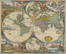
Detailed map of the World, showing tracks of Captain James Cook in his 3 voyages in great detail. The map is extensively annotated with information on the explorations of a number of regions on the map in the 1770s, primarily deriving from Cook. New Zealand is shown. Australia retains it's a mostly conjectural mid-18th Century Coastline. No sign of Antarctica. Fascinating transitional mapping of Alaska and NW America. Small hole below the eastern hemisphere, else a nice example of the map, one of the first World maps printed in America.
![Newsmap. Monday, July 27, 1942 [on verso:] Tanks of the British Army](https://storage.googleapis.com/raremaps/img/small/93349.jpg)
![[ Ancient World ] Christianographie](https://storage.googleapis.com/raremaps/img/small/80305.jpg)
![[Rare Complete Example with Game Pieces] Grand Circuit Des Capitales. Collection Concours Du Chocolat Menier](https://storage.googleapis.com/raremaps/img/small/70922rd.jpg)