|
||

|

|
|

|
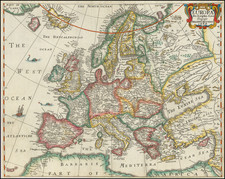
Glorious old color example of the first state of Waghenaer's map of Europe, the British Isles, Iceland, the western Mediterranean, and much of North Africa and the Western Atlantic, including the mythical Island of Brazil. Richly embellished with compass roses, sea monsters, sailing ships, coats of arms and rhumb lines. The map appeared in an early edition of Waghenaer's Speigel der Zeevaerdt and is characterized by the curious circular representation of Iceland, which was revised in the second edition. Waghenaer's Spiegel was the first engraved sea atlas, making this search chart of Europe and the Western Atlantic the earliest printed sea chart of the region. The engraving work of Joannes Doetecum is very much in evidence. Because this map was significantly larger than the other maps in the atlas, it rarely appears on the market in good condition. The present example is an unusually nice example, with narrow upper and lower margins (but no loss of neatline, as is often the case), and good side margins. Latin text on the verso. A fine example of this highly important map.
![[ European Cooperation ] Organisation Europeenne de Cooperation Economique](https://storage.googleapis.com/raremaps/img/small/78837.jpg)