


|
||

|

|
|

|
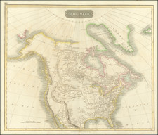
Outstanding map of North America, extending to the North Pole, from Thomson's General Atlas. One of the best early 19th Century atlas maps of North America, treating with remarkable detail the up to date explorations in the Northwest and in search of a northwest passage. An early map to report the discoveries of Lewis & Clark. All of the California Missions are shown. Fort Vancouver and Mt. Hood are shown, but there is little or no information on the Columbia River. A fair amount of Indian detail is shown, especially in Canada and west of the Missouri River, based upon Lewis & Clark. Wheat notes that the upper Missouri is based upon Soulard. Minor fold split top and bottom, else a nice example. Wheat 319.
John Thomson (1777-ca. 1840) was a commercial map publisher active in Edinburgh. He specialized in guide books and atlases and is primarily known for his Atlas of Scotland (1832) and the New General Atlas, first published in 1817 and reissued for the next quarter century. The New General Atlas was a commercial success—it was also published in Dublin and London—and it compiled existing geographic knowledge in compelling ways for a wide audience.
His Atlas of Scotland introduced new geographic information and was the first large-scale atlas of Scotland to be organized by county. It provided the most-accurate view of Scotland available before the Clearances. Work on the atlas began in 1820 and led to Thomson’s bankruptcy in 1830 due to the high costs of gathering the latest surveys and reviewing the required materials. Despite the publication of the atlas, Thomson declared bankruptcy again in 1835.
![[Anchorage, Valdez and Prince William Sound] Cote Nord-Ouest De L'Amerique Reconnue par le Cape. Vancouver VIe. Partie . . .](https://storage.googleapis.com/raremaps/img/small/92676.jpg)