


|
||

|

|
|

|
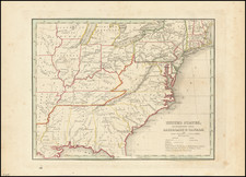
Fascinating map of the Midwest and Northeastern Colonies, only 9 years after the end of the American Revolution. The map is most notable for the many land grants shown Western Territory, which then included Ohio, Tennessee and the Old Northwest Territory. The grants include Illinois Company, Army Lands, Wabash Company, New Jersey Company, Ohio Company, and the 7 Ranges, along with the Donation Lands from the Commonwealth of Virginia and General Clark's Grant 1500 acres. Many settlements are noted in the West, along with early forts (Miami, Pitt, Venango, Chartres) and other interesting features. St. Louis appears on the map, as does Louisiville, St. Genevieve, New Madrid, St. Philips, Cahokir, and the Kaskaskais Village. A nice post-revolutionary war map of the region. The present example has a fold split which is unevenly repaired an old repaired tear at the right side of the map wher it was bound into the book. There is no loss at the right margin. The folds were backed at an early time to support some old paper splits. Pehaps the best feature of the map is the extensive not on the verso, dated January 5, 1838, describing Lake Superior, the largest lake in the known world. The note includes extensive information on the lake, including its depth, the number of streams that feed the lake and many other notes.

![[Anchorage, Valdez and Prince William Sound] Cote Nord-Ouest De L'Amerique Reconnue par le Cape. Vancouver VIe. Partie . . .](https://storage.googleapis.com/raremaps/img/small/92676.jpg)