


|
||

|

|
|

|
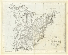
Rare outline color example of this important map of the United States, from the second folio atlas printed in America and the first in New York. Missisiipp Territory is drawn in and named in manuscript, as are Indian and Ohio. Excellent detail in Jefferson's Northwest Territory. Many Indian Tribes noted. The various lands given in Illinois east of the Mississippi River to the veterans of the American Revolution are named, including Illinois Company, New Jersey Company, and Wabash Company. In Ohio, the Seven Ranges and Army Lands are noted. Tennessee is Tennessee Government. A reference to the 10 new states established by Jefferson in 1784 is incluided, but the states are not delineated with borders. A bit of soiling, but a nice example of this scarce map.
Following Mathew Carey’s publication of the American Atlas in 1795, the second large format atlas published in America was produced by John Reid of New York in 1796. The project began as an atlas to accompany William Winterbotham’s An Historical, Geographical, Commercial and Philosophical View of the United States, but was also sold separately under the title The American Atlas.
Reid’s atlas included 20 maps. In addition, John Russell’s plan of Washington, D.C. is also bound into some copies of the Atlas. Reid’s atlas was a collaborative work, with 9 of the maps engraved by Benjamin Tanner, 5 by David Martin, two by D. Anderson and one each by John Scoles and John Roberts. Two of the maps do not include engraving credits. Each of the engravers was probably working in New York (including Tanner, who had not yet relocated to Philadelphia). According to the various entries for the maps in Wheat & Brun, the cartographic content of the maps is drawn largely from Carey’s first atlas of 1795.

![The Travellers Guide or Map of The Roads, Canals & Rail Roads of the United States, With the distances from Place to Place By H.S. Tanner 1845 [with] The American Traveller, or Tourists' and Emigrants' Guide Through The United States . . . .](https://storage.googleapis.com/raremaps/img/small/99038.jpg)
![[ Los Angeles Olympics ] O Limp Hicks Loose Anglaise Calif. 1932](https://storage.googleapis.com/raremaps/img/small/90509.jpg)
![[Hand Drawn Map] Le Golfe de Mexique avec les Pays Circonvoisins](https://storage.googleapis.com/raremaps/img/small/91580.jpg)