This item has been sold, but you can enter your email address to be notified if another example becomes available.


|
||

|

|
|

|
Stock# 14405
Description
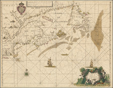
Highly detailed 18th Century map of the British and French Colonies in North America, on the eve of the French & Indian War. Includes many forts, villages, Indian placenames, and early colonial settlements, including excellent details west of the Mississippi River, and in the Great Lakes and Texas regions. An early appearance of the newly formed Georgia Colony (which interestingly does not extend to the Mississipp River). From Schreiber's Atlas Selectus. A nice example in old color.