


|
||

|

|
|

|
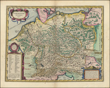
A large and impressive map of Central Europe including Hungary, the Danube Delta, Transylvania, Walachia, Moldavia, Croatia, Bosnia, Dalmatia, Slavonia, Morlachia and the Republic of Ragusa.
Distressed and warring figures appear alongside the title cartouche, while the powerful and triumphant Hapsburgs, as indicated by the double-headed eagle, stand above the defeated figures of the Ottoman Empire. The map emphatically depicts this European supremacy. A bit of soiling at upper fold, else a gorgeous example.
The Ottens brothers, Reiner and Joshua, operated a successful printing partnership in the mid-eighteenth century (fl. 1726-1765). They began the venture in 1726, publishing maps and other prints as “R & I Ottens.” They specialized in the reprinting of others’ work, especially Guillaume De L’Isle. In 1750, Reiner died; his soon, also Reiner, took his place, but the firm began listing their works as “Joshua & Reiner Ottens.” The firm lasted until Joshua’s death in 1765. Joshua’s widow, Johanna de Lindt, sold their remaining stock of plates in 1784.
![[ Budapest ] Plan de la Ville et des Attaques de Bude. en 1686](https://storage.googleapis.com/raremaps/img/small/86460.jpg)
![(Northern Scandinavia) Carte des Couronnes du Nord Dediée Au très Puissant et très Invincible Prince Charles XII, Roy de Suède, des Gots et des Vandales, Grand Duc de Finlande, &c. &c. &c. [Map of the Northern Crowns Dedicated to the Very Powerful and Invincible Prince Charles XII, King of Sweden, of the Goths and Vandals, Grand Duke of Finland, etc. etc. etc.]](https://storage.googleapis.com/raremaps/img/small/92675.jpg)
![Von den Sieben burgen [Siebenberg / Transylvania]](https://storage.googleapis.com/raremaps/img/small/78330.jpg)