


|
||

|

|
|

|
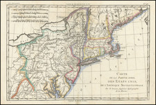
Rare example of Vander Aa's depiction of John Smith's map of the region between Virginia and Long Island. Includes a marvelous depictions of the Chisapeack Bay and Long Island, with many early Indian place names, along with a few early Dutch names on Long Island, plus Fort Ellenburg in the Delaware Bay, Smith's Falls and a few other references to European place names. Vander Aa was one of the great compilers of early voyages. Many of these voyages did not include contemporary maps, making Vander Aa's accounts, the only obtainable graphical representations of the voyage. Gorgeous full color with a striking cartouche. This map rarely appears on the market. A fine example with nice margins.
Pieter van der Aa (1659-1733) was a Dutch mapmaker and publisher who printed pirated editions of foreign bestsellers and illustrated books, but is best known for his voluminous output of maps and atlases. Van der Aa was born to a German stonecutter from Holstein. Interestingly, all three van der Aa sons came to be involved in the printing business. Hildebrand was a copper engraver and Boudewyn was a printer.
![Carte Particuliere de Virginie, Maryland, Pennsilvanie, La Nouvelle Jarsey. Orient et Occidentale [Heighten in Gold!]](https://storage.googleapis.com/raremaps/img/small/61392mp2.jpg)
![(Civil War) Fredericksburg … [with] Map… of the Sioux Expedition [with] Map of the Fight of the 14th A.C. Buzzard Roost, GA [and ] Big Mound [and] Dead Buffalo Lake [and] Dry Fort Creek](https://storage.googleapis.com/raremaps/img/small/97072.jpg)

![[ First Map of Pennsylvania Province ] A Map of the Province of Pensilvania Drawn from the Best Authorities By T. Kitchin Gr.](https://storage.googleapis.com/raremaps/img/small/98226.jpg)