


|
||

|

|
|

|
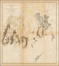
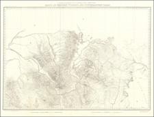
Large format map of Kansas, Nebraska, Dakota and part Colorado and Wyoming, extending as far southeast as Denver, Colorado City and St. Vrains. Excellent detail of railroads including the Union Pacific, showing two parallel routes one ending in Denver the other a little north and heading into Wyoming and off the map. Dozens of forts located. Numerous routes of explorations and surveys are drawn in. Areas roamed by principal Indian Tribes are shown. Warren's extensive knowledge of the area and his skill as a cartographer are obvious in this large, detail-filled map. Geology of eight different groups is indicated by hand coloring. Geology was provide by Dr. Ferdinand Hayden, then Professor of Geology and Mineralogy at the University of Pennsylvania, and only 4 years prior to his famous trip of exploration into Yellowstone that resulted in Yellowstone becoming the first National Park in the United States. The map accompanied Hayden's Final Report of the United States Geological Survey of Nebraska and Portions of the Adjacent Territories, (42d Congress 1St Session House of Representatives Ex. Doc. No. 19), published in 1872. Linen backed, with a bit of loss along a few folds, but generally an excellent example of this remarkable map, which rarely appears on the market.
Ferdinand Vandeveer Hayden, known to the Sioux as "man-who-picks-up-stones-running," stands among the pantheon of eminent geologists of the 19th century.
Hayden's academic career commenced at Oberlin College, and he furthered his education at Albany Medical College, where he received his M.D. in 1853. Despite his medical training, Hayden was primarily engaged in geology, a field to which he would dedicate his life's work.
Hayden commenced his geological career with a survey in the Nebraska Territory in 1856. In 1859 and 1860, he conducted further exploratory work in the Rocky Mountains, particularly in Colorado, which was then part of the Nebraska and Kansas territories. His early work in the field earned him the respect of Native American tribes, with the Sioux reportedly dubbing him "man-who-picks-up-stones-running" due to his avid and energetic collection of geological samples during his expeditions.
By the 1860s, Hayden had risen to prominence as a geologist and was appointed the United States Geologist for the Geological Survey of the Territories. This role would define his career, leading numerous surveys in the Western United States. Notably, from 1871 to 1872, Hayden led a survey into the region that would become Yellowstone National Park, and his reports significantly contributed to the establishment of Yellowstone as the first National Park in 1872.
Hayden's most significant contribution to geological literature was the Geological Atlas of Colorado, published in 1877. This work was the result of comprehensive surveys conducted across Colorado, meticulously documenting the state's geography and geology. The atlas offered detailed maps on a scale previously unseen, encompassing not only Colorado but adjacent areas, including parts of Utah, Arizona, and New Mexico.
Hayden's influence extended to academia, as he was affiliated with the University of Pennsylvania for a period, where he held the position of professor of geology. His academic and field work combined to form a substantial body of knowledge that would be used by future scholars and explorers.
Ferdinand V. Hayden passed away on December 22, 1887, in Philadelphia, Pennsylvania. His enduring legacy is reflected in the numerous natural features named after him, including Hayden Valley in Yellowstone and Mount Hayden in Colorado. His contributions to geology during the 19th century remain a cornerstone of American geological and geographical sciences.

![[ Hungarian Traveler In the California and the West with a Comanche and Wichita to Hungarian vocabulary ] Levelei Éjszakamerikából -- Tizenkét eredeti rajzok után készült kő- és egynéhány fametszettel. Közli Prépost István (Letters from North America)](https://storage.googleapis.com/raremaps/img/small/98502.jpg)