
This item has been sold, but you can enter your email address to be notified if another example becomes available.


|
||

|

|
|

|
Stock# 13580
Description
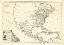
Scarce map of a portion of the US, from Lake Michigan to Kentucky and Virginia to Maine. Includes a curiously misshaped Ohio and a massive Indiana, which extends from the Ohio River to Lake Huron and Lake Michigan, incorporating all of what would become Michigan (except the Upper Peninsula) and Illinois. The detail in Virginia is also noteworthy for the period. This is the largest treatment of Indiana we have ever seen. Issued in the year after Indiana's Statehood, with no mention of the Territory of Illinois or the Territory of Michigan. A marvelous map for Indiana collectors.

![[Eastern Sheet -- Ohio] Post Road Map of the States of Ohio and Indiana with Adjacent Parts of Pennsylvania Michigan Illinois Kentucky and West Virginia Showing Post Offices With The Intermediate Distances and Mail Routes In Operation On the !st of February 1885 . . .](https://storage.googleapis.com/raremaps/img/small/44153.jpg)
![[ Catholic Dioceses and Missions in the United States ] Karte der katholischen Dioecesen und der en Missionen in Nordamerika nach den nuesten geographischen Angaben... 1845](https://storage.googleapis.com/raremaps/img/small/98630.jpg)
![Vereinigte Staaten von Nord-Amerika [Views of New York City and Back Country Scenes]](https://storage.googleapis.com/raremaps/img/small/25442.jpg)