|
||

|

|
|

|
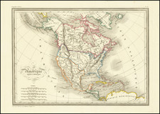
Detailed map of America, showing showing North America immediately prior to the discoveries of Lewis & Clark. The map is dated 1808 and includes an unkown region west of the Rocky Moutains, pre-Humboldt configuation for the Rockies, limited knowledge of Louisiana Territory and NW Coast based upon Cook and Vancouver. California is New Albion and Upper California. Several rivers reach tentatively from the Missisipppi to the Pacific Ocean, but none with definite routes. Salt Lake is Pearl Shell Lake. The Missions of Upper California are noted. The Upper Missouri reaches hopefully for a water route to the Pacific. Massive Western Territory is shown. A few contemporary pencil notes. Alaska is Russian Terrirtory. Attractive and detailed. From Smith's General Atlas.
![[ Exceptional original hand-color with highlights in gold ] Typus Aspectuum Oppositionum Et Coniunctionum Etz In Planetis](https://storage.googleapis.com/raremaps/img/small/81866.jpg)
![[Fruit Crate Label Advertising Map] Panama Brand (North America & Panama Canal)](https://storage.googleapis.com/raremaps/img/small/48860.jpg)