|
||

|

|
|

|
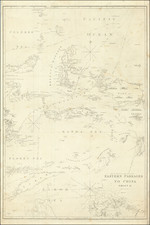
Gorgeous early Dutch sea-chart of Australia and the East Indies, based in part on Pieter Goos' chart of 1666. The chart is oriented with north to the left of the page and covers the region from the Indian subcontinent to Japan and including much ofthe coastline of early Australia. Japan is shown on the Blaeu-Martini model. The coastlines of Western Australia are based on early Dutch discoveries and the surveys of Abel Tasman during his two milestone voyages of the early 1640's. The first state of the map, pre-dating the addition of Tasmania presaent in the Ottens editions. Gorgeous full color example, with wide clean margins. Tooley, Mapping of Australia, page 205, #40, pl. 100; Clancy, The Mapping of Terra Australis, # 6.13.
De Wit (1629 ca.-1706) was a mapmaker and mapseller who was born in Gouda but who worked and died in Amsterdam. He moved to the city in 1648, where he opened a printing operation under the name of The Three Crabs; later, he changed the name of his shop to The White Chart. From the 1660s onward, he published atlases with a variety of maps; he is best known for these atlases and his Dutch town maps. After Frederik’s death in 1706, his wife Maria ran the shop for four years before selling it. Their son, Franciscus, was a stockfish merchant and had no interest in the map shop. At the auction to liquidate the de Wit stock, most of the plates went to Pieter Mortier, whose firm eventually became Covens & Mortier, one of the biggest cartography houses of the eighteenth century.
![[ Sichuan and Shaanxi ] Suchuen et Xensi, Provincia seu Praefecturae Regni Sinensis . . .](https://storage.googleapis.com/raremaps/img/small/95627.jpg)