


|
||

|

|
|

|
Melish's map of the United States, first issued in 1816, is widely regarded as the most important map of the United States issued in the 19th Century.
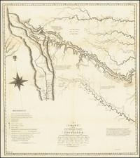
In his treatise on the map, Walter Ristow identified 25 states of the map, including several so-called proof states. Among the proof states, Ristow noted the existence in the Library of Congress of the only known example of what he then described as the first state of the 1820 edition of the map. Ristow noted that of this state only the southeast sheet, including the title cartouche and the West Indies inset map, exists. He surmised that this unique sheet was likely a proof sheet from an intended update in 1820 which was never issued, as all other known states of the 1820 edition (7 states) were issued in 9 sheets, with the geographical content extended 7 degrees further south). Perhaps because all other states in 1820 are of the enlarged edition of the map, Ristow assumed that his unique 1820 example of the south east sheet must certainly have pre-dated the others issued in 1820.
We offer here the only known example of the south central sheet of Ristow's so-called 1st state of the 1820 edition, extending from the Rocky Mountains and New Mexico to Alabama Territory, Arkansas Territory and parts of Missouri, Tennessee, Kentucky and Illinois, centered on Texas. The discovery of this sheet also calls into question the accuracy of Ristow's observations that this is in fact a proof of the 1st state. It also introduces the prospect that the 6 sheet edition was a late 1820 state, issued after Ristow's 5th state. As with the sheet identified by Ristow, this south central sheet ends at 23 degrees north latitude, making it the sheet directly west of the sheet identified by Ristow. In all other respects, the map includes the changes which distinguish the final state of the 1818 edition of the map from the second state of the 1820 edition.
What is perhaps even more interesting is that the map includes changes in Texas and Mexico not identified by Ristow until the 5th state of the 1820 edition, most notably the changes in Texas, including the reference to La Salle's establishment in 1683, R. de la Trinidad, R. Brassos, (unnamed) Fort, Pas del Caballo, S. Bernards Bay, I. De S. Luis, R. Colorado, R. De Flores, R. De Sn Marcos, etc. Ristow's possible failure to note these changes on the second, third, and fourth editions invites all sorts of speculation. Ristow notes that in his first state of the 1820 edition, in the copyright notice, the numeral 1 has been inserted in ink before the 6, to make it read 16th of June 1820. The date 16th of June is not noted in print until the 4th state. Therefore, it appears quite possible that Ristow's 1st state of the 1820 was in fact issued AFTER Ristow's 4th state. Additional evidence of this change is that in the present example, the words Ceded to the U.S. by Treaty appear AFTER the name Florida in the statistical table below Louisiana. Further confusing matters, Ristow suggests that beginning in the 5th state, the words Ceded to U.S. by Treaty should appear BEFORE Florida, not after. This would appear to be an error in Ristow's description. This table was removed in Ristow's 8th state of the 1820 edition. It would appear that Ristow erred in describing the unique single sheet in the possession of the Library of Congress as the first state of the 1820. Almost certainly, it was issued sometime after the 5th state and before the 8th state, when the statistical table was removed.
Regardless of the answer, the present map is apparently the only known example of the south central sheet of what may have been a proof example of a 6 sheet map issued in 1820. We have not compared our example to the example in the Library of Congress, but it would appear that this example was never joined. The present example has two minor stains and has been laid on modern linen, but is generally in very nice condition. A unique opportunity to own the only known example of this cartographic landmark.
John Melish (1771-1822) was the most prominent American mapmaker of his generation, even though his cartographic career lasted only a decade. Melish was born in Scotland; he moved to the West Indies in 1798 and then to the United States in 1806. By 1811, he had settled in Philadelphia and published Travels through the United States of America, in the years 1806 & 1807, and 1809, 1810, & 1811, which was richly illustrated with maps.
Melish created several regional maps of the highest quality, as well as the Military & Topographical Atlas of the United States (Philadelphia, 1813, expanded 1815). The latter work is widely considered to be the finest cartographic publication to come out of the War of 1812.
By far his best-known work is his monumental map of the United States of 1816, Map of the United States with the contiguous British and Spanish Possessions. He began working on the map in 1815 and sent it to Thomas Jefferson for comment in 1816. Jefferson enthusiastically reviewed the map and returned it with his edits. Jefferson later hung an example of the map in the Entrance Hall of Monticello and sent it to associates in Europe.
Melish’s finished product was the first map of the United States to extend to the Pacific Ocean. After its publication in 1816, Melish ensured the map was as up-to-date as possible; it was reissued in 25 known states published between 1816 and 1823. The map captured the then rapidly changing geography of the United States, as well as various boundary disputes, treaties, and expansion.

![[Utah] Amer. Sep. No. 47. Partie Du Mexique](https://storage.googleapis.com/raremaps/img/small/88711.jpg)
![[ Texas Oil Map ] Map of Terrell County Texas](https://storage.googleapis.com/raremaps/img/small/102589.jpg)
![(Texas) Denkschrift über eine Reise nach Nord-Mexiko, verbunden mit der Expedition des Obersten Donniphan, in den Jahren 1846 und 1847. Von Dr. A. Wislizenus. Aus dem Englischen übertragen von George M. von Ross. Mit einem wiffenschaftlichen Anhange und drei Karten. [Description of a voyage to northern Mexico connected with Colonel Doniphan's expedition in 1846 and 1847 By Dr. A. Wislizenus. Translated from the English by George M. von Ross. With a scholarly appendix and three maps.]](https://storage.googleapis.com/raremaps/img/small/88574.jpg)