
![A New and Exact Map of the Dominions of the King of Great Britain on ye Continent of North America . . . [Beaver map] By Herman Moll](https://storage.googleapis.com/raremaps/img/small/101277.jpg)


|
||

|

|
|

|
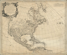
Attractive full color example of Moll's seminal Beaver map, one of the most sought after of all collector's maps. One of the most famous and important 18th Century maps to show the British Colonies and claims in North America. Published shortly after the War of Spanish Sucession, it is a vivid counter-attack on De L'Isle's territorial claims on behalf of the French. A wealth of descriptive detail provides information on such politically important topics as the British alliance with the Iriqouis and French Fishing Rights in Newfoundland. There is also an excellent description of the Colonial Postal Routes, including mail routes and delivery times. Includes a number of excellent insets, including a large inset of the Carolinas and one of Charleston. Copies of the Beaver map have become increasingly difficult to obtain, with auction prices reaching over $40,000 in the past year. This example includes some expert restorations along the neatlines, reaching just entering the printed image, although confined to the neat line areas, and a two inch centerfold split. In all, a very attractive example of this hard to find map.
Herman Moll (c. 1654-1732) was one of the most important London mapmakers in the first half of the eighteenth century. Moll was probably born in Bremen, Germany, around 1654. He moved to London to escape the Scanian Wars. His earliest work was as an engraver for Moses Pitt on the production of the English Atlas, a failed work which landed Pitt in debtor's prison. Moll also engraved for Sir Jonas Moore, Grenville Collins, John Adair, and the Seller & Price firm. He published his first original maps in the early 1680s and had set up his own shop by the 1690s.
Moll's work quickly helped him become a member of a group which congregated at Jonathan's Coffee House at Number 20 Exchange Alley, Cornhill, where speculators met to trade stock. Moll's circle included the scientist Robert Hooke, the archaeologist William Stuckley, the authors Jonathan Swift and Daniel Defoe, and the intellectually-gifted pirates William Dampier, Woodes Rogers and William Hacke. From these contacts, Moll gained a great deal of privileged information that was included in his maps.
Over the course of his career, he published dozens of geographies, atlases, and histories, not to mention numerous sheet maps. His most famous works are Atlas Geographus, a monthly magazine that ran from 1708 to 1717, and The World Described (1715-54). He also frequently made maps for books, including those of Dampier’s publications and Swift’s Gulliver’s Travels. Moll died in 1732. It is likely that his plates passed to another contemporary, Thomas Bowles, after this death.

![Trails: [1595-1945]: Land, Sea, and Air of The American Adventure Series](https://storage.googleapis.com/raremaps/img/small/70672.jpg)
![(Rhode Island Coastal Defenses) [9 Engineering Plans for Barbette Batteries and Related Fortifications]](https://storage.googleapis.com/raremaps/img/small/92401.jpg)
![[Signed Political Satire Artwork] Vietnam ... Vietnam ... Vietnam ...](https://storage.googleapis.com/raremaps/img/small/68726.jpg)