
The item illustrated and described below is sold, but we
have another example in stock. To view the example which
is currently being offered for sale, click the
"View Details" button below.


|
||

|

|
|

|
Stock# 1174
Description
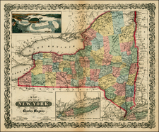
Rare separately issued map of the state of New York, issued by Charles Magnus. Mangus published birdseye views, letter sheets and separately issued maps during the Civil War. This map was apparently intended to be issued in pocket map format, but was never folded. The map is colored by counties and shows railroads, common roads, canals, towns, rivers, and a host of other information. Insets of Long Island and a large view of Niagara Falls. This example was part of a remainder collection which was never folded. It has been archivally mountained on linen and is virtually flawless, save for a split and crease down the middle. A marvelous copy of a rare pre-Civil War decorative map of the US.